
Unlocking the Power of Spatial Data
At HawarIT, we specialize in cutting-edge GIS and remote sensing services, offering tailored solutions that harness the full potential of spatial data. Our expertise lies in capturing, processing, and analyzing geospatial information to provide invaluable insights for a wide range of industries.
Our Remote Sensing Services:
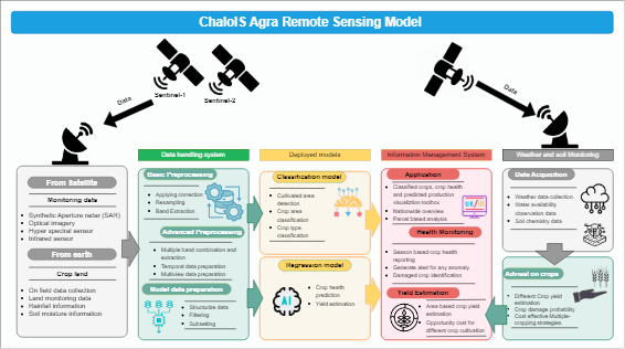
- Remote Sensing: Utilizing state-of-the-art technology, we capture high-resolution satellite imagery, aerial data, and drone footage to collect detailed information about the Earth’s surface. Our remote sensing capabilities empower industries such as agriculture, forestry, environmental monitoring, and more.
- GIS Mapping: We excel in Geographic Information System (GIS) mapping, creating detailed and interactive maps that enhance decision-making processes. Whether you need to analyze terrain, plan infrastructure, or visualize spatial relationships, our GIS solutions are tailored to meet your specific requirements.
- Data Analysis: Our team of skilled analysts employs advanced data processing techniques to extract meaningful patterns and trends from spatial data. From land cover classification to change detection, we deliver actionable insights that drive informed decision-making.
- Custom Solutions: Recognizing that every project is unique, we offer customized solutions to address your specific challenges. Our team works closely with clients to understand their goals and develop GIS and remote sensing strategies that align with their objectives.
Why Choose HawarIT
- Expertise: Our team of geospatial experts brings extensive knowledge and experience to every project.
- Cutting-Edge Technology: We stay at the forefront of technological advancements to provide the latest and most accurate spatial data solutions.
- Tailored Approach: We understand that each client has unique needs, and we tailor our services to deliver customized solutions.
Explore the power of spatial data with HawarIT. Contact us today to discuss how our GIS and remote sensing expertise can elevate your projects to new heights.